Property Record
100 Momeni Ln Se, Adairsville, GA 30103


NEARBY LISTINGS FOR SALE OR LEASE
Property Detail
100 Momeni Ln Se
048-002
Owr Llc
Industrialacreage
Gordon
A
Georgia
13015C0050H
174&175
2024
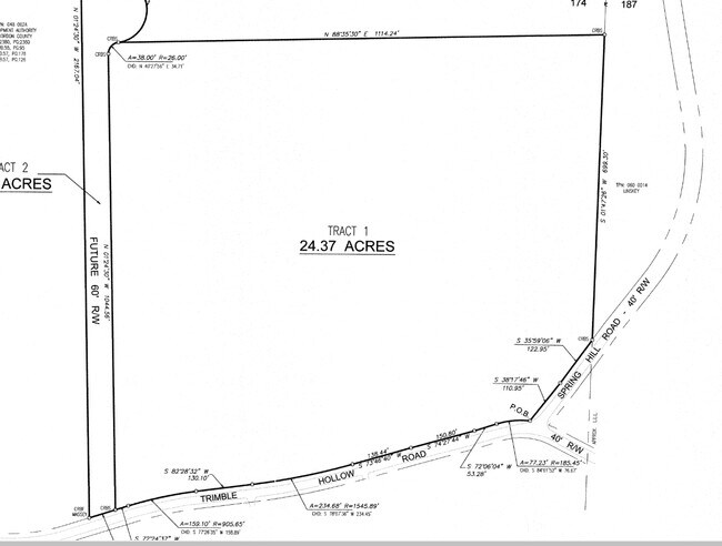
24.37 AC
2024
Georgia Northwest
960202
Other Market Areas
304,308 SF
Calhoun, GA
DEMOGRAPHICS near 100 Momeni Ln Se
1 Mile
3 Mile
5 Mile
2024 Total Population
219
6,322
18,344
2029 Population
238
6,918
19,866
Pop Growth 2024-2029
+ 8.68%
+ 9.43%
+ 8.30%
Average Age
39
38
39
2024 Total Households
86
2,371
6,812
HH Growth 2024-2029
+ 8.14%
+ 9.24%
+ 8.10%
Median Household Inc
$47,857
$67,010
$57,725
Avg Household Size
2.60
2.70
2.70
2024 Avg HH Vehicles
2.00
2.00
2.00
Median Home Value
$191,666
$194,474
$180,959
Median Year Built
1993
2000
1992
Nearby Places
Map Layers
Map Styles
 Street
 Aerial
- Restaurants
- Banks
- Shops
- Fitness
- Groceries
SALE & LEASE HISTORY
LISTING DATE
SALE/LEASE

Nov 02, 2020
For Lease
Aug 12, 2020
For Sale
Nearby Properties
Address
Land Use
TOTAL SIZE
Lot Size
Zoning
Address
Land Use
TOTAL SIZE
Lot Size
Zoning
1,038,487 SF
80.91 AC
I-2
Address
Land Use
TOTAL SIZE
Lot Size
Zoning
675,935 SF
63.15 AC
I-2
Address
Land Use
TOTAL SIZE
Lot Size
Zoning
740,998 SF
55.39 AC
IND-G
Address
Land Use
TOTAL SIZE
Lot Size
Zoning
430,100 SF
Address
Land Use
TOTAL SIZE
Lot Size
Zoning
445,290 SF
37.89 AC
I-2
Address
Land Use
TOTAL SIZE
Lot Size
Zoning
926,772 SF
64.21 AC
Address
Land Use
TOTAL SIZE
Lot Size
Zoning
63.15 AC
I-2
Address
Land Use
TOTAL SIZE
Lot Size
Zoning
63.15 AC
I-2
Address
Land Use
TOTAL SIZE
Lot Size
Zoning
495,040 SF
Address
Land Use
TOTAL SIZE
Lot Size
Zoning
670,659 SF
115.64 AC
IN
Address
Land Use
TOTAL SIZE
Lot Size
Zoning
394,200 SF
32.57 AC
Address
Land Use
TOTAL SIZE
Lot Size
Zoning
403,152 SF
8.33 AC
Address
Land Use
TOTAL SIZE
Lot Size
Zoning
769,184 SF
49.82 AC
IN
Address
Land Use
TOTAL SIZE
Lot Size
Zoning
660 SF
81.59 AC
IN
Address
Land Use
TOTAL SIZE
Lot Size
Zoning
740,750 SF
30.22 AC
IND-G
Address
Land Use
TOTAL SIZE
Lot Size
Zoning
474,912 SF
54.83 AC
IND-G
Address
Land Use
TOTAL SIZE
Lot Size
Zoning
408,600 SF
38.92 AC
I-2
Address
Land Use
TOTAL SIZE
Lot Size
Zoning
549,997 SF
138.47 AC
IND-G
Address
Land Use
TOTAL SIZE
Lot Size
Zoning
497,640 SF
31.58 AC
Address
Land Use
TOTAL SIZE
Lot Size
Zoning
444,267 SF
70.09 AC
Address
Land Use
TOTAL SIZE
Lot Size
Zoning
454,680 SF
5.23 AC
IND-G
Address
Land Use
TOTAL SIZE
Lot Size
Zoning
228,119 SF
19.25 AC
IN
Address
Land Use
TOTAL SIZE
Lot Size
Zoning
554,520 SF
60.95 AC
IN
Address
Land Use
TOTAL SIZE
Lot Size
Zoning
114,989 SF
14.35 AC
IN
Address
Land Use
TOTAL SIZE
Lot Size
Zoning
4.16 AC
IN
Address
Land Use
TOTAL SIZE
Lot Size
Zoning
89,298 SF
25.68 AC
I-2
Address
Land Use
TOTAL SIZE
Lot Size
Zoning
300,000 SF
17.48 AC
IN
Address
Land Use
TOTAL SIZE
Lot Size
Zoning
860,400 SF
19.85 AC
IND-G
Address
Land Use
TOTAL SIZE
Lot Size
Zoning
96,647 SF
35.06 AC
I-2
Address
Land Use
TOTAL SIZE
Lot Size
Zoning
205,158 SF
20.63 AC
IN
The World's #1 Commercial Real Estate Marketplace
Connect with us
© 2026 CoStar Group
The information above has been obtained from sources believed reliable. While we do not doubt its accuracy we have not verified it and make no guarantee, warranty or representation about it. It is your responsibility to independently confirm its accuracy and completeness. Any projections, opinions, assumptions, or estimates used are for example only and do not represent the current or future performance of the property. The value of this transaction to you depends on tax and other factors which should be evaluated by your tax, financial, and legal advisors. You and your advisors should conduct a careful, independent investigation of the property to determine to your satisfaction the suitability of the property for your needs.